
Improvements to Waldo Drain

In late June of 2017, while the rest of Michigan was enjoying mild temperatures and cloudy summer weather, the Great Lakes Bay Region was enduring extreme storms. While the frightening thunder, lightning, and wild wind gusts were enough to make the storm memorable, nobody was prepared for the extensive rainfall that left many residents, like the ones in Larkin Township, significantly impacted by the historic flooding and water damage.
Larkin Township is located in the northern part of Midland County and is home to over 5,000 residents. It is one of many communities affected by the large storm events in 2017.
Many properties within Larkin Township experienced extensive flooding. These properties needed drainage improvements to help capture and drain the water, especially in the spring when much of the runoff occurs. This led to a petition being filed by Larkin Charter Township with the Midland County Drain Commissioner in March 2018, for the renovation of the Waldo and Branches Intercounty Drain, which is the backbone of the drainage system collecting the storm water throughout multiple municipalities in both Midland and Bay Counties. The Waldo and Branches Intercounty Drain was in need of maintenance to help prevent community-wide flooding from occurring again and also provide an outlet for future drainage systems.
The Waldo Drain, which was constructed in 1905 for agricultural and residential purposes to help minimize flooding, stretches just over 20 miles from the Kawkawlin River in Beaver Township in Bay County northwest into Larkin Township in Midland County. There are 123 drain crossings throughout the 20 miles of open drain and a watershed area of 26,672 acres. It also serves a total of 2,200 parcels of property with 1,156 of those parcels being in Bay County.
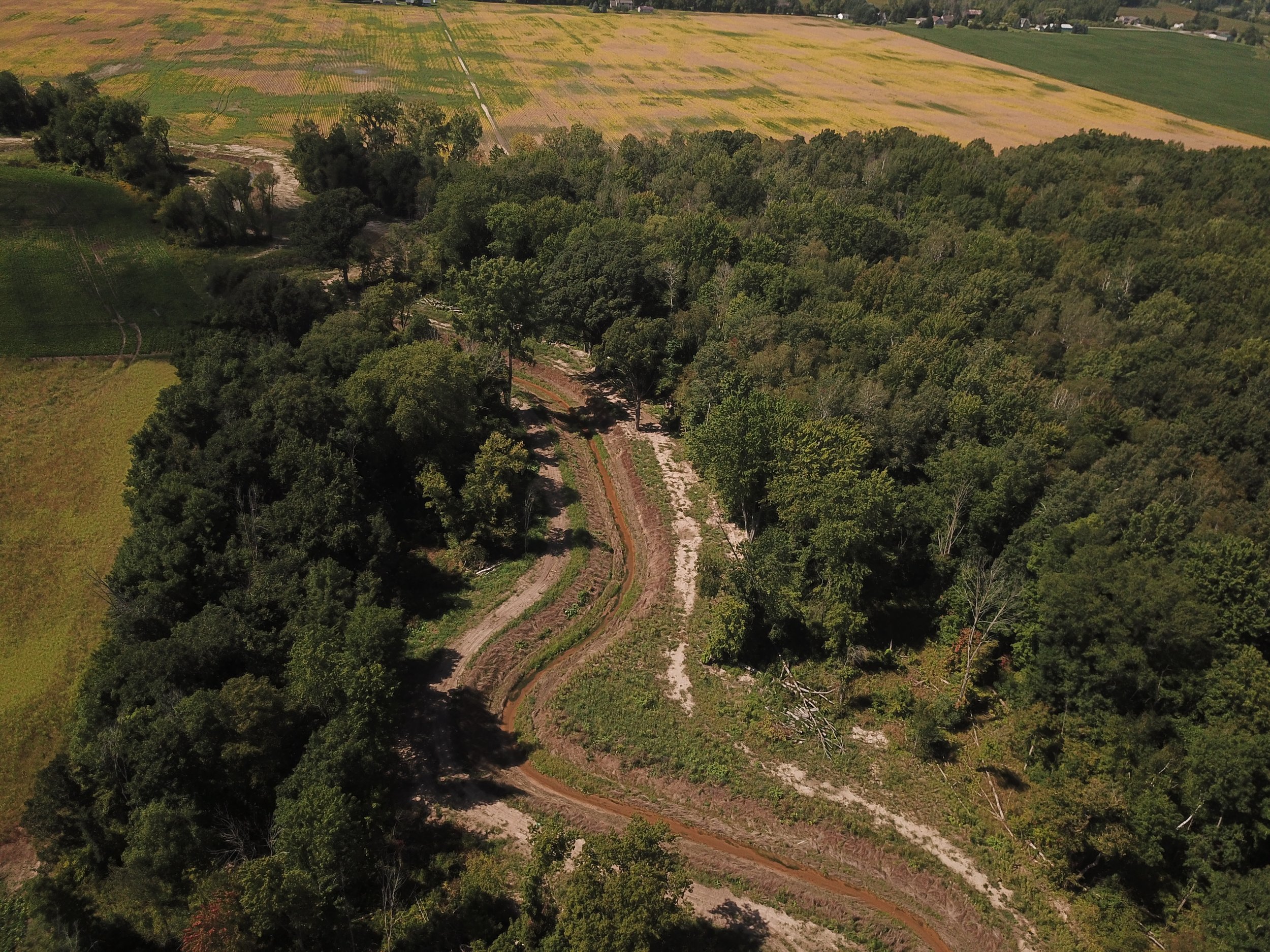
“Waldo Drain starts off as a very large open-channel drain surrounded by agricultural land and as you get closer to Larkin Township, where it is more urbanized, the drain branches off into many smaller open channels that are connected to the main branch.” Spicer Group project manager, Nick Czerwinski, P.E., said.
In May of 2018 a Hearing of Practicality was held which featured testimony of poor drainage and flooding. Many community members were present to voice their concerns about the continuous flooding of their neighborhoods. After the significance of the problem was addressed, it was then determined to move forward with an engineering evaluation of the Waldo and Branches Intercounty Drain.
Spicer Group was hired that same month to perform a condition survey which consisted of inspection of the drain and all of its features. This included identifying elevation of drain channels, and depth of sediment at each drain crossing along with size and material of the culverts. The survey identified areas with heavy sediment build up, log jams, standing water and vegetation obstructions. It was concluded that the drain would need clearing, excavation, and cleanout of the channels, along with erosion control and improvements to drain crossings and road shoulders.

After the topographic survey and preliminary engineering was complete, Spicer Group presented these findings at a Hearing of Necessity on June 17th, 2019. It was concluded that a project was necessary and construction of the Waldo Drain project would move forward. Spicer Group was hired to perform final engineering, design, and construction administration work for the project.
Spicer Group surveyors conducted a topographical survey which looked at the drain and all elements within 50 feet of it. This was crucial for designers to create the plans for the restorations needed which included the replacement of many culverts and widening of the drainage channel.
The construction work on the drain is being provided by Bilacic Trucking. This includes the installation of concrete box culverts, corrugated metal pipe arches and HP storm pipe.
The project team selected a two-stage channel design as opposed to a more conventional trapezoid shaped channel.
This gives the channel a larger cross-sectional area which helps to prevent flooding and reduce erosion.
The two-stage channel design relies on a narrow and shallow low-flow channel centered between two “shelves” or “benches”. Day-to-day flows stay concentrated in the low flow channel keeping velocity high enough so that sedimentation in the drain bottom is reduced. During a larger event the water spills out onto the shelves on the second stage which slows the high-flows down to prevent erosion of the channel banks.
The implementing of a two-stage channel is also a great cost saving measure when space is available. It allows for less use of hard armoring in erosion-prone areas due to the design. It also allows for a reduction in maintenance costs due to the reduced rate of sediment accumulation associated with the design.
The project costs totaled roughly $5.4 million and is expected to be completed in Spring of 2022. As the next storm rolls through the Township residents will be calmer knowing flooding has been mitigated.
