
Gratiot County Maintenance Requests
From the Phone to the Field Using ESRI Survey123
In Gratiot County the expanses of corn, soybeans, and sugar beets are underpinned by 1270 miles of county drain. Supporting this network of drains, Drain Commissioner Bernie Barnes oversees a staff of four: Chief Deputy Carol Siggers, Project Manager and Deputy Joe Sherwood, Assessment Clerk and Deputy Jennie Bollinger, and Deputy Emma Hansen. Barnes relies on Joe Sherwood to provide boots-on-the-ground field investigation and inspections.
UNTIL THIS YEAR, keeping track of phone calls, field investigations and subsequent drain maintenance relied heavily on paper reports and phone calls. Hansen and Bollinger used to receive phone calls from landowners then log the call to a paper maintenance request, and Sherwood would have to either retrieve the maintenance request from the office or receive a phone call directing him to urgent problems.
This workflow required hours of driving to and from the drain office located in the city of Ithaca. Field inspections were logged on paper forms while pictures were taken with phones or cameras requiring back-office post processing to prepare finalized inspection reports. The drain office had been using desktop ArcGIS software for years to review drain jurisdiction, right of way, and maintenance history. With COVID-19 necessitating the ability to decentralize from the office, Barnes knew there had to be a better way of utilizing this GIS and managing maintenance requests. He called Max Clever, P.E., P.S., at Spicer Group to provide a solution that utilized his existing ESRI licenses.
Request Focused Maintenance
After a brief meeting between Barnes and Clever, the following capabilities were identified as crucial to the success of the adoption of the new system:
Connect all work to a drain number and individual maintenance request
Document phone calls
Record field investigations
Create report to send to contractors to perform work
Record inspections of construction work
Create reports of inspections and save to drain files
ESRI’s Survey123 was identified as the optimal platform to achieve all these objectives as the tool is multiplatform capable, modifying reports is quick, and most importantly it is included with the existing maintenance package for users of ArcGIS Pro, which the drain office already had.
Recording the phone calls, or office visits requesting maintenance is a vital step in supporting the decision to perform work on a drain. Now, using a web app on their desktop, office staff log new phone calls directly to maintenance requests using the Survey 123 webpage. With this map-centric workflow, office staff can decide whether follow-up phone calls and additional conversations can be logged as new maintenance requests or appended to existing requests.
Field Investigations
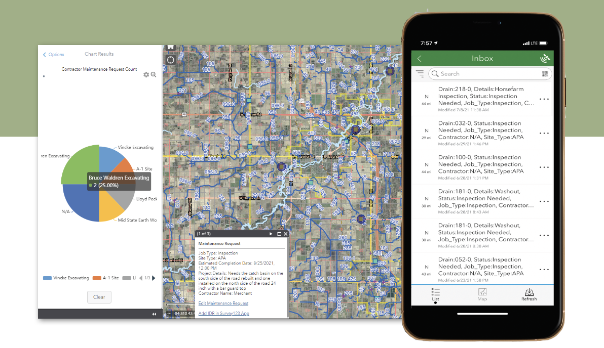
Once created, new maintenance requests are made available for review in the field using the Survey 123 phone app. Being filtered by a status of “Inspection Needed,” this app acts as a live to-do list for field investigations. Also, by utilizing an inbox, Survey 123 can operate completely offline and allow users to upload work later when they have internet.
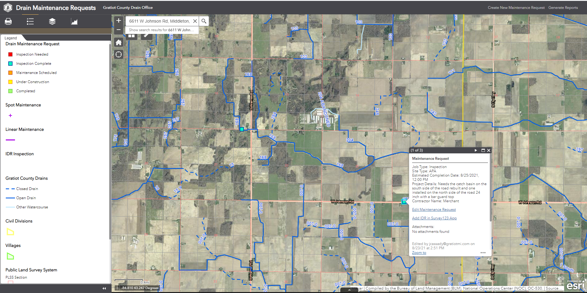
While the maintenance request is a beginning point for the investigation for problems in the field, the actual proposed maintenance is mapped and photographed on related points and lines to specify what work is required to solve the problems in the field. Recording maintenance on a separate layer allows for more comprehensive instructions to be sent to the contractor.
Subcontracting Maintenance
Previously, one of the most time-consuming tasks in the office was to compile all the documents and photos related to the maintenance request and package it into a document that could be sent to contractors. Now, with Survey 123 reporting the prior phone calls, field investigation can be bundled and exported to either PDF or Word documents and sent to the contractor.
In heavy construction months, the drain office may want to check on which contractors they have currently working on jobs. A simple pie chart shows which contractors are currently under contract.
Construction Inspection
Performing construction inspection was another process that used to take extra time in packaging up photos and notes to form individual IDR reports. Again, using the Survey 123 reporting tool, these inspections are printed to PDF or Word as a final monument of the work that was done on the job.
Forecast – Cloudy
Although Gratiot County had been using ArcGIS desktop for years, the online GIS aspect of the platform had formerly been either too limited or too reliant on accessory server tools to really be an option. It has been nearly 10 years since ArcGIS online was released. Survey 123 as a platform is even newer, having been released in 2015 and the reporting tools in 2019. Creating reports from field-collected GIS information had been something that required ArcGIS Enterprise. At the pace that ESRI keeps adding functionality, it serves drain offices well to stay tuned to what features might come next.