
Mapping Railroad Assets
Spicer Group’s mobile mapping capabilities continue to be a key component in providing infrastructure asset management solutions for clients

The Michigan Department of Transportation Office of Rail (MDOT) manages 665 centerline miles of state-owned railroad corridor in Michigan’s Lower Peninsula. These include five lines that are operated on a contract basis by five freight railroad companies. There is an intercity passenger rail service provided by Amtrak that operates on a 135-mile-line between Kalamazoo and Dearborn—known as the Michigan Line.
Similar to a highway or public utility system, railroads have their unique set of assets that play a role in their safety, reliability and function. Everything from crossing arms to mile post signs, switch points and mechanisms to overpass clearances and even overhanging vegetation are key assets that make up a railway system, and each has their own unique attributes. To get a comprehensive understanding and accurate record of all assets along its railroad corridors, MDOT pursued an initiative to develop a comprehensive asset management program for its rail assets.
“Ultimately, with MDOT’s implementation of its overall Transportation Asset Management System (TAMS), the Office of Rail is focused on integrating its asset management plans and developing a program that ties its assets into the overall TAMS system,” Spicer Group Principal Eric Barden, P.S. said.
MDOT’s first task was to inventory its assets geospatially so each asset has an accurate spatial component. Once inventoried, the assets can be integrated into MDOT’s TAMS GIS environment, and a linear referencing system developed. However, accomplishing this across 665 miles of active railway was not a simple task and required alternative methods of data collection.
“MDOT’s Survey Support Unit selected us to perform the work, and our first task was to evaluate the best method to spatially inventory the required assets for the entire Lower Peninsula rail network,” Barden said. “We identified various data collection technologies for consideration, and a cost benefit analysis was prepared for each method, and in some cases, a combination of methods. Ultimately a hybrid approach, using Airborne LiDAR, hi-rail mounted mobile LiDAR, Unmanned Aerial Vehicles (UAV) and conventional survey techniques, was identified as the best approach to maximize value and ensure efficiency.”

One-inch pixel nadir image of rail yard.
Airborne LiDAR was used to collect data while minimizing impact to Michigan’s busiest rail corridor known as the Michigan Line—the Amtrak passenger service line from Kalamazoo to Dearborn. Hi-rail-truck-mounted mobile LiDAR was chosen to collect a large portion of the remainder of the rail network. Track access and obtaining permits was much easier for these rail sections, and once coordinated, Spicer staff were able to quickly drive the hi-rail truck equipped with Spicer’s Pegasus Mobile LiDAR sensor to collect the data.
Some areas of tracks had not been used in several years and had experienced significant vegetation growth including encroaching tree canopies and growth through tracks, so these areas required the use of conventional surveying techniques. Spicer Group’s Unmanned Aerial Vehicles came in handy when working around congested rail yards where significant train traffic was present. Staff used the UAVs equipped with high-resolution digital cameras to collect photogrammetric data and develop a 3D model of the yard and tracks.

Mobile LiDAR data showing vertical clearance measured via interactive web-based viewer.
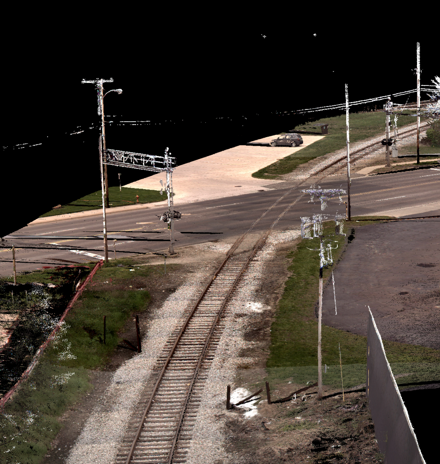
True color point cloud generated from Pegasus Mobile LiDAR sensor.
“Our team combined all data into a single, seamless data source detailing MDOT’s current assets of concern including track centerline, milepost signs, points of switch and points of frog, frog being the point at which the left and right rails cross in a switch,” Barden said. “Data related to these assets has been organized and delivered to MDOT’s Office of Rail through a simple viewing service accessible by anyone, anywhere through a standard web browser, with immersive 3D viewing and measurement capabilities.”
MDOT’s Office of Rail staff can now view every inch of railway and all visible assets under their ownership at any time on a computer or smart phone. They can measure various object distances and sizes, see welds in tracks, and even view an asset’s condition at the time of collection. This unique ability will help them plan for life cycle costs on key assets, identify potential areas of concern, and the opportunity to maintain a digital record of assets within the railroad rights of way—all contributing to the reliability and safety of the railway system.
“After reviewing the data Spicer Group collected, all I can say is WOW,” Rob Lippert, MDOT’s Railroad Infrastructure Section Manager said. “The work Spicer Group has done for MDOT is great. This will be the foundation of MDOT’s railroad asset management. We will now be able to accurately locate, report on and map our assets. Better information will lead to better decisions.”
Rail-view image from rear camera of Pegasus Mobile LiDAR sensor.