Cedar Lake Lake Level Control Structure
Residents and users of Cedar Lake can rest easy due to recently completed improvements to a key piece of infrastructure that helps maintain the lake.

Cedar Lake is located in both Alcona and Iosco Counties near Oscoda, Michigan. The 5.9-mile-long lake is around 1,075 acres in size and is relatively shallow averaging less than five feet deep.
“Cedar Lake is unique because it has a very small drainage area and doesn’t receive any inflow from artesian or free-flowing springs or rivers,” Spicer Group project manager Warren Miller, P.E. said. “For the most part, the lake relies on direct precipitation from rain, snow and minor groundwater flows from the watershed to recharge its level.”
In 1954, as part of a circuit court order to maintain a legal lake level, a control structure was built on the north end of the lake where Cedar Creek outflows. Improvements were made to the control structure in 1979 and additional repairs were made in 2012. Although some repairs were made, the control structure still had other structural issues, and was given a failed rating by the Michigan Department of Natural Resources for 15 years straight.
Cedar Lake outlets to Cedar Creek and flows downstream to Lake Huron. It becomes a dedicated cold water trout stream along the way. The original control structure was in poor condition and would become obstructed frequently by debris, which would result in higher water levels and flooding in various areas surrounding the lake.

“Because of the unique topography of the lake, many of the 800 landowners were subject to flooded properties if the lake elevation rose above its normal legal lake level more than 3 inches,” Miller said. “Flooding would cause structure damage and threatened septic systems around the lake. This fact, and the deteriorating ability of the original control structure to safely convey water out of the lake during times of heavy precipitation prompted the lake owners and the Alcona and Iosco County Drain Commissioners to pursue a reliable fix.”
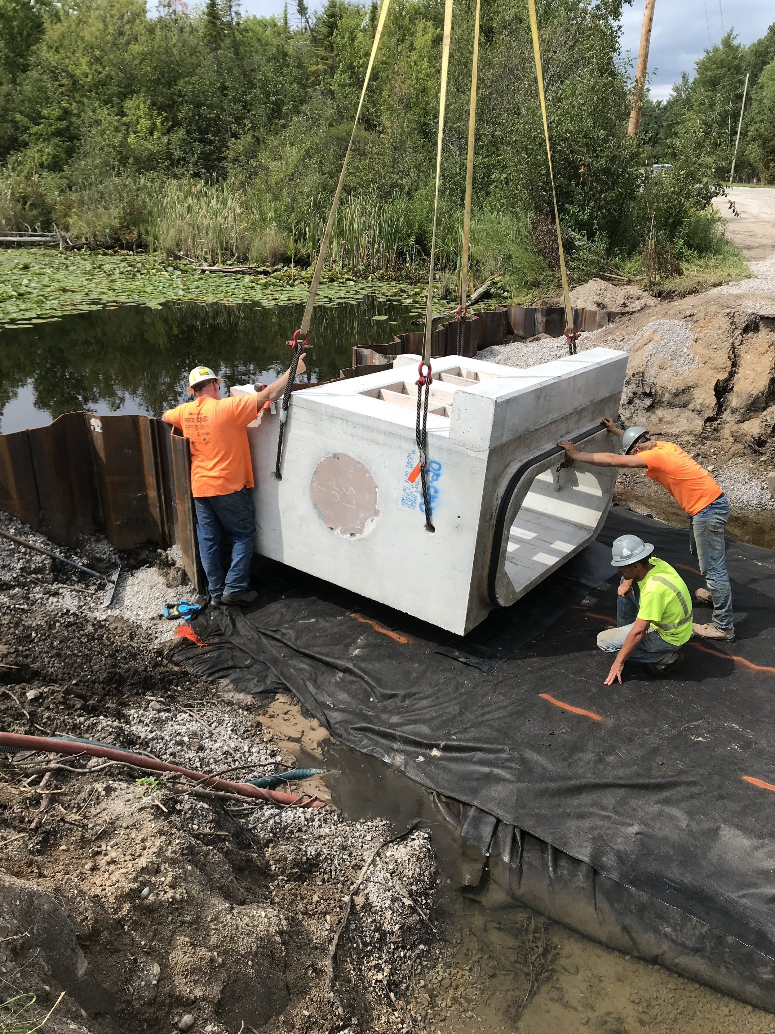
Spicer Group was contracted to assist with designing a new control structure, amending the existing Part 307 Legal Lake Level, and establishing a special assessment district to fund these efforts. Improvements included removal of the old structure and constructing an entirely new structure that consisted of installing a sheetpile weir and a 7-foot by 3-foot box culvert.
The team had to come up with a crafty solution to construct a structure that would allow enough water to remain in the lake for users to enjoy it for fishing and boating, but also pass enough water to eliminate the threat of flooding during periods of heavy precipitation. This was done by designing and constructing a high-flow weir and a low-flow weir.
“The new lake level control structure was sized to convey the 100-year flood event, per the Department of Environment, Great Lakes and Energy (EGLE) Michigan Dam Safety unit,” Miller said. “The existing dual corrugated metal pipe structure was replaced by a pre-cast seven-foot span by three-foot rise concrete box culvert. The pre-cast structure, comprised of eight sections, allowed for expedited installation to minimize the closure to Cedar Lake Road, which is the primary method to round the lake from the north end.”
Upstream of the concrete structure, approximately 80 feet of steel sheet pile (SSP) was installed to span the upstream channel. The SSP served two purposes, the first being to aid in water control during installation of the box culvert, and the second being the permanent weir which would be set at two elevations to convey low flows and high flows.

The center portion of the SSP was constructed to be the low-flow weir which allows for normal flows to be conveyed through the structure and also maintain the Part 307 Normal Lake Level of 608.2 referenced to the North American Vertical Datum of 1988 (NAVD88). The low-flow weir is seven feet wide and is 1.8 inches lower than the remaining 73 feet.
Using hydraulic modeling, many iterations were performed to determine the appropriate elevations to set the high-flow weir. This was a delicate process as if the lake level exceeded the Part 307 level, more than 3” flooding was observed in various areas along the lake. Utilizing spot elevation data collected by the project’s survey crew, the team identified the low areas surrounding the lake and used that as the basis to set the high-flow weir elevation of 608.3 NAVD88. The purpose of the high-flow weir is to quickly convey water through the structure and allow for much greater capacity as the water elevation of the lake rises.
A critical design factor, in addition to regulating the Part 307 normal achieved lake level and reducing flooding, was by utilizing redundant inlets. This also provided additional capacity if any of the inlets became obstructed during a storm event. The new structure was designed to pass much more debris through the structure, and this is accomplished by the low-flow inlet, which is at the center of the structure. The low-flow weir’s two-foot by seven foot opening allows vegetative material and small woody debris to be flushed through the box culvert.
An area downstream of the structure was cleared, and a maintenance lane was established to allow for more routine maintenance and removal of deposited material. This process is much more efficient, unlike the previous structure where even the smallest material would obstruct the grating and would greatly reduce the capacity of the structure.
In addition to the main opening, four pre-cast concrete catch basins were installed adjacent to the structure to provide additional redundant inlet capacity. Lastly, immediately to the north of the main opening two, 2.5-foot by 3.75-foot grated openings were made part of the pre-cast end section of the box culvert. Again, this provides redundant inlet capacity in high flow scenarios.
The Cedar Lake project was originally scheduled to be completed during the winter but due to environmental restrictions the work had to be completed in summer. Thankfully the year of 2021 was rather dry, and the lake was naturally low which helped facilitate construction of the structure. If that was not the case, additional water control and temporary sheeting would have been needed to complete the project.